
Summary
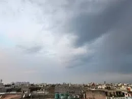
Residents in Chandigarh, Punjab, and Haryana are getting a short break from the rain this weekend before stormy weather returns. The India Meteorological Department has announced that a new yellow alert will begin on Monday and last until Thursday. This follows a week of heavy rain, hail, and strong winds that kept the region much cooler than usual for this time of year. While Saturday and Sunday will be dry and clear, people should prepare for thunderstorms and fast winds starting early next week.
Main Impact
The biggest impact of this weather shift is the return of unpredictable storms after a very brief period of calm. The yellow alert means that while the weather might not be dangerous every minute, there is a strong chance of sudden thunderstorms and lightning that could disrupt daily life. These storms are expected to bring winds reaching speeds of up to 40 kilometers per hour. For farmers and those working outdoors, this means another week of protecting crops and equipment from wind and rain. Additionally, temperatures are expected to rise quickly during the dry days, making the air feel much warmer before the next round of rain arrives.
Key Details
What Happened
Over the past week, the region dealt with several intense storms caused by a weather system known as a Western Disturbance. This brought near-record rainfall to some areas and even caused hailstorms in parts of Punjab and Haryana. On Friday, the weather began to settle down, though some areas still saw light rain and cool breezes. This cooling effect has kept the heat away for a few days, but the atmosphere is now shifting again. The upcoming yellow alert indicates that the region is entering another active weather cycle that will bring scattered rain across all three areas from Monday through Thursday.
Important Numbers and Facts
The weather data shows just how unusual the recent days have been. Chandigarh has recorded over 100 mm of rain since March, which is about 166% more than what is normally expected during this season. On Friday, temperatures in Chandigarh were nearly 5 degrees Celsius lower than the average for May. While most places stayed in the low 30s, Sirsa in Haryana was the hottest spot, reaching nearly 40 degrees Celsius. Forecasters expect the maximum temperature to jump by 4 to 6 degrees Celsius over the next few days as the sun comes out fully during the weekend break.
Background and Context
In this part of India, May is usually one of the hottest months of the year. However, Western Disturbances—which are weather systems that travel from the Mediterranean region—can bring sudden moisture and cool air. When these systems hit the plains of Punjab and Haryana, they often clash with the rising summer heat, leading to thunderstorms and hail. This year, these systems have been particularly strong, which is why the region has seen so much more rain than usual. The "yellow alert" is a way for the weather office to tell the public to "be aware" and stay updated, as the weather could turn bad quickly even if it looks clear in the morning.
Public or Industry Reaction
The reaction to this weather has been mixed. Many residents are happy about the cooler temperatures, as May is typically a month of extreme heat and power cuts. The rain has provided a natural cooling effect that has made the outdoors more pleasant. However, the agricultural sector remains cautious. Frequent storms and hail can damage ripening crops or interfere with the drying of harvested grains. Commuters in the cities have also faced challenges with waterlogged roads and traffic delays during the heavy downpours seen earlier in the week. Most people are now using the dry weekend to finish outdoor chores before the next set of storms arrives on Monday.
What This Means Going Forward
As we move into next week, the weather will likely be a mix of heat and sudden storms. The rise in temperature during the weekend will provide the energy needed for thunderstorms to form by Monday. Residents should expect Monday and Tuesday to be the most active days for rain and wind. It is important to secure loose items outside and avoid standing under trees or near power lines during the gusty winds. After Thursday, the weather office expects conditions to ease again, but the pattern of frequent disturbances suggests that the typical summer heatwaves might be delayed or interrupted again later this month.
Final Take
The upcoming week will be a test of patience for those living in the northwest plains. While the weekend offers a perfect chance for outdoor activities and clear skies, the return of the yellow alert on Monday serves as a reminder that the stormy season is not over yet. Staying informed and watching the sky will be key to staying safe and dry as these weather patterns continue to shift.
Frequently Asked Questions
What does a yellow alert mean?
A yellow alert is a warning from the weather department to "be aware." it means the weather could get worse and people should stay updated on local forecasts to avoid being caught in a storm.
Will it rain all day from Monday to Thursday?
No, the rain is expected to be "isolated," which means it will happen in some spots but not everywhere at once. The storms will likely be short but could bring strong winds and lightning.
Is the weather going to get hotter this weekend?
Yes, temperatures are expected to rise by 4 to 6 degrees Celsius on Saturday and Sunday because there will be no rain and fewer clouds to block the sun.