
Summary
The India Meteorological Department (IMD) has issued a yellow alert for Chandigarh, Punjab, and Haryana. This warning is in place from Monday, May 11, through Thursday, May 14. Residents should expect thunderstorms, lightning, and strong winds during this period. While the weekend started with dry weather, the coming days will bring a significant shift in the local climate. This alert serves as a notice for people to stay informed and take necessary precautions as the weather turns more active.
Main Impact
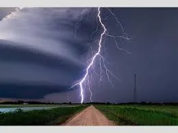
The primary impact of this weather update is the risk of sudden and strong thunderstorms across the region. These storms are expected to bring gusty winds moving at speeds between 40 and 50 kilometers per hour. Such winds can be strong enough to blow away loose objects or break small tree branches. Along with the wind, isolated areas will see rainfall and lightning strikes. This change follows a period of rising temperatures, meaning the sudden shift could affect daily commutes and outdoor work schedules for many people in the Tricity and surrounding states.
Key Details
What Happened
After a dry Saturday and a calm Sunday, the weather office predicts a change starting Monday. The "Tricity" area, which includes Chandigarh, Mohali, and Panchkula, will see partly cloudy skies on Sunday before the storms arrive. The most intense weather is expected on Monday and Tuesday. During these two days, the threat of lightning and heavy wind is at its highest. By Wednesday, the conditions will start to calm down, though the sky will remain cloudy. By Friday, the weather is expected to be dry again, and the warning will be lifted.
Important Numbers and Facts
The IMD has shared several important figures regarding the current weather trends. Temperatures are expected to rise by 4 to 5 degrees Celsius over the next three days. In the Tricity area, daytime highs will likely stay between 35°C and 37°C. Nighttime temperatures will also be warmer, ranging from 22°C to 25°C. Interestingly, the region has already seen a lot of rain this year. Since March 1, Chandigarh has recorded 100.8 mm of rainfall. This is 162.5 percent higher than the usual amount for this time of year, showing that this spring has been much wetter than average.
Background and Context
In this part of India, May is usually one of the hottest months of the year. It is common to see temperatures climb as the region moves toward the peak of summer. However, pre-monsoon activities like thunderstorms often provide temporary relief from the heat. A "yellow alert" is a specific type of warning used by the weather department. It does not mean there is an immediate disaster, but it tells people to "be aware." It suggests that the weather could get worse and might cause some problems for those who are not prepared. This year, the weather has been more unpredictable than usual, with rainfall levels far exceeding the normal limits for the past two months.
Public or Industry Reaction
Local authorities are keeping a close watch on the situation. Farmers in Punjab and Haryana are often the most affected by sudden rain and strong winds, as these conditions can impact crops that are being stored or processed. In the cities, people are being advised to secure their belongings and avoid standing under tall trees or near electric poles during the storms. The rise in temperature before the rain has also led to an increase in the use of cooling systems, as both days and nights are becoming noticeably hotter. In Punjab, cities like Bathinda have already seen temperatures near 39.1°C, while Sirsa in Haryana hit 39.4°C, making them the hottest spots in their respective states.
What This Means Going Forward
Looking ahead, the heat is likely to return once the rain stops. While the thunderstorms will bring a brief cooling effect, the overall trend for May is a steady increase in temperature. The dry weather predicted for the coming weekend suggests that the heatwave conditions might intensify later in the month. For now, the focus remains on the four-day window of the yellow alert. People should plan their travel carefully between Monday and Thursday to avoid being caught in a sudden storm. Local power companies may also be on standby in case the gusty winds cause any damage to the electricity grid.
Final Take
The upcoming week will be a mix of rising heat and sudden storms for Chandigarh and the neighboring states. While the rain might offer a short break from the sun, the strong winds and lightning carry real risks. Staying updated with the latest weather reports will be the best way to stay safe during this period of active weather. As the region moves deeper into May, these shifts between extreme heat and sudden rain are likely to become more frequent.
Frequently Asked Questions
What does a yellow alert mean for the weather?
A yellow alert is a signal from the weather department to "be aware." it means that the weather might change for the worse and could cause minor disruptions, so people should stay informed.
Which areas will be most affected by the rain and wind?
The alert covers Chandigarh, Punjab, and Haryana. Specifically, the Tricity area (Chandigarh, Mohali, and Panchkula) is expected to see the most active weather on Monday and Tuesday.
How fast will the winds be during the thunderstorms?
The winds are expected to be gusty, reaching speeds between 40 and 50 kilometers per hour. These winds will likely be accompanied by lightning and rain at isolated places.