
Summary
A sudden and powerful storm hit the Chandigarh tricity area in the early hours of Monday, bringing strong winds and heavy rain. The storm caused immediate power cuts and interrupted water supplies across many neighborhoods. Although the weather turned calm by sunrise, weather experts have issued a serious warning that the most intense part of the storm is still to come. An orange alert remains active for the region as wind speeds are expected to increase significantly over the next 24 to 48 hours.
Main Impact
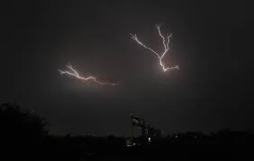
The primary impact of this weather event is the threat of high-speed winds and lightning. The weather office has warned that wind speeds could reach between 50 and 70 kilometers per hour. These gusts are strong enough to break tree branches, damage small buildings, and knock down power lines. While the initial storm at 2 am was short, it served as a preview of the more unstable weather expected to arrive late Monday evening and continue through Tuesday.
Key Details
What Happened
The storm began around 2 am on Monday, catching many residents by surprise. For about an hour, heavy winds and thunder battered Chandigarh, Mohali, and Panchkula. This led to widespread electricity failures as the wind affected the power grid. Most services were fixed by the morning, but the sky remained cloudy and unsettled throughout the day. Meteorologists explained that this is caused by a "Western Disturbance," which is a weather system currently sitting over North Pakistan and moving toward India.
Important Numbers and Facts
The India Meteorological Department (IMD) has set specific alerts for the coming days. An orange alert, which means "Be Prepared," is in place for Monday and Tuesday. During this time, winds will likely stay between 50 and 60 kmph, with some gusts reaching 70 kmph. From Wednesday to Friday, the warning will drop to a yellow alert, meaning "Stay Updated," with winds slowing down to 40 or 60 kmph.
Rainfall has already been recorded in several areas. Pathankot saw 19 mm of rain, while Ropar received 18 mm. Interestingly, while the winds were strong in Chandigarh, the city center recorded almost no measurable rain during the Monday morning storm. However, the region has seen a very wet season overall, with rainfall levels sitting at 161% above the usual average since March.
Background and Context
A Western Disturbance is a common weather pattern in Northern India. It involves a system of low pressure that brings moisture from the Mediterranean region. When these systems move over the mountains and plains of Pakistan and India, they often cause sudden storms, rain, and a drop in temperature. This specific system is moving at about 3.1 kilometers above sea level. It is expected to be quite active for a few days before it finally moves away toward the end of the week.
Public or Industry Reaction
Weather officials have issued strict safety advice for the public. People are encouraged to stay inside during the peak of the storm and move away from windows. Because lightning is a major risk, residents should avoid standing under tall trees or near electric poles. Farmers in Punjab and Haryana have been told to stop their work in the fields until the storm passes to avoid injury or crop damage. For those driving, the advice is to pull over to a safe spot and stay inside the car if the wind becomes too strong or visibility drops.
What This Means Going Forward
The next two days will be the most difficult as the orange alert continues. Residents should expect possible disruptions to water and electricity again. However, once this storm system leaves on Friday, the weather will change quickly. The forecast shows that the clouds will clear by Saturday, leading to a sharp rise in heat. Temperatures are expected to hit 40°C for the first time this season by the weekend. This means the region will go from stormy, cool weather to intense summer heat in just a few days.
Final Take
While the early morning storm caused some minor trouble, the real test for the region's infrastructure and residents will be the high-speed winds predicted for Tuesday. Staying informed and following safety guidelines is essential during this period of unstable weather. Once the wind and rain stop, the focus will quickly shift from storm safety to managing the first major heatwave of the year.
Frequently Asked Questions
What does an orange alert mean?
An orange alert is a warning from the weather department that tells people to "Be Prepared." It means that bad weather is very likely and could cause disruptions to daily life, travel, and power supplies.
How strong will the winds be this week?
Winds are expected to blow between 50 and 60 kmph on Monday and Tuesday, with some sudden gusts reaching as high as 70 kmph. By Wednesday, the winds should slow down slightly to around 40 to 60 kmph.
When will the weather return to normal?
The stormy weather is expected to last until Friday. By Saturday, the skies will clear, the rain will stop, and the weather will become very hot, with temperatures reaching up to 40°C.